Contributing to OpenStreetMap
Jan 20, 19 openstreetmapSometimes I get asked how exactly one contributes to OpenStreetMap (OSM). The OSM Wiki page has a good portal with a wide array of information on how to contribute, so this post is going to focus more on how I specifically go about contributing to give some perspective on a single person view.
Surveying
Surveying hearkens back to the roots of OSM, with Steve Coast riding around rural England collecting GPS traces of roads to come home and input into the database. Surveying is something you can do fairly readily whenever you have free time–whether on vacation, commuting, or shopping–and could be either planned or unplanned. Planned surveying may be taking a day trip down to another part of town that I live in to explore, a long layover in an airport I have never been to, or a free afternoon in a city I am vacationing in. Unplanned surveying is more along the lines of me having fifteen minutes free near a part of town I have not been to or me sitting at a particularly long traffic light in a bus or car. Surveying in this sense may elicit images of people in orange vests with theodolites, but this surveying is much more informal.
When going on a planned survey, I make sure to bring along a few tools that will be helpful: pen and paper, a cap, and maybe a cell phone. The pen and paper allow me to sketch the area I am surveying and label points of interest. Because OSM tagging is user driven, you can map anything and everything in reality! I tend to focus on points of interest (POIs) such as stores, restrooms, water fountains, address numbers, and other amenities since there is so much missing still in the US in OSM. Here are a few examples of survey notes I have made:
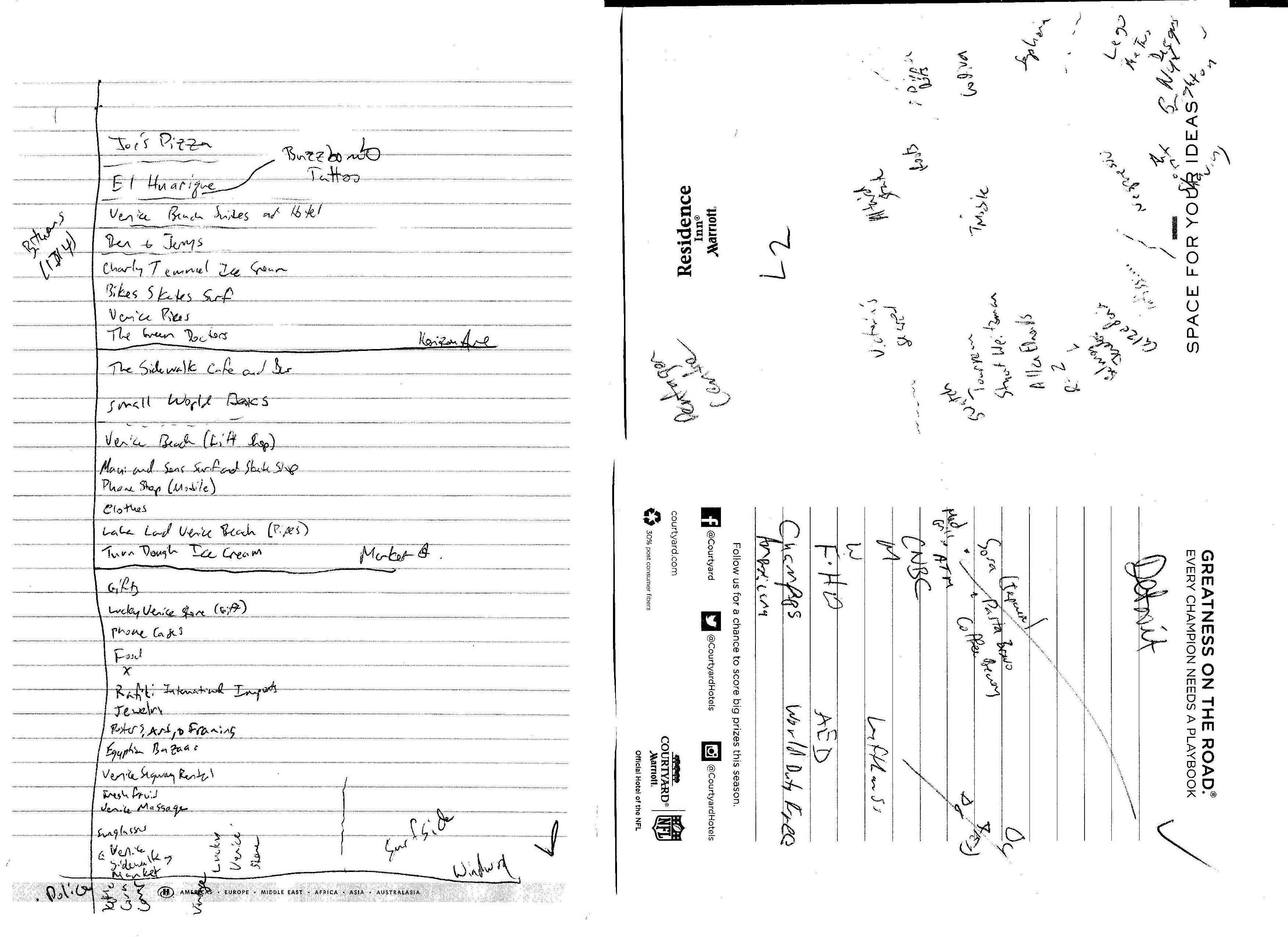
Note particularly for the airport in the bottom right that there are some abbreviated codes. This is done best as a user-developed technique, rather than trying to remember someone else’s scheme. Restrooms for example I label by M (male), W (women), F (family or unisex), and H or H2O (water fountain). Obviously female and family would clash with the same first letter, so I have rationalized in my head that it is easier to remember M and W, but that not may be the same with someone else. Keeping the cognitive load low will help you recall more when you inevitably cannot understand one part of your survey notes and have to go by memory.
You may also note these notes are not to scale. Rather than making an exact sketch of places I survey, I like to take note of specific landmarks that will help orient me when it comes to inputting this data back at home (see below for more information) so that I can maximize the amount of data while minimizing the amount of paper space. Many companies like Microsoft, Mapbox, DigitalGlobe, and ESRI have graciously donated satellite imagery for use with OpenStreetMap, so I use those to put the orienting landmarks in context.
I also bring a cell phone along when surveying. Usually this is so I can listen to music or a podcast, but it also helps at times to take photos of certain situations. I find photos that I can reference very helpful particularly in areas of dense POIs or very difficult spacing. I could perhaps spend four or five minutes sketching that complex layout, but I am not an artist so the photo will ensure I get it right. To me, taking photos of everything gets messy since it can be hard to determine direction, order, and context (but not impossible). Just remember not to take photos of other maps!
The final step to surveying is actually inputting the data into OpenStreetMap. I try to perform this task as soon as possible after the survey while the full experience is fresh in my mind. It may be the case that I did not sketch something in the most illuminating fashion (even with landmarks) so that memory will help resolve minor issues.
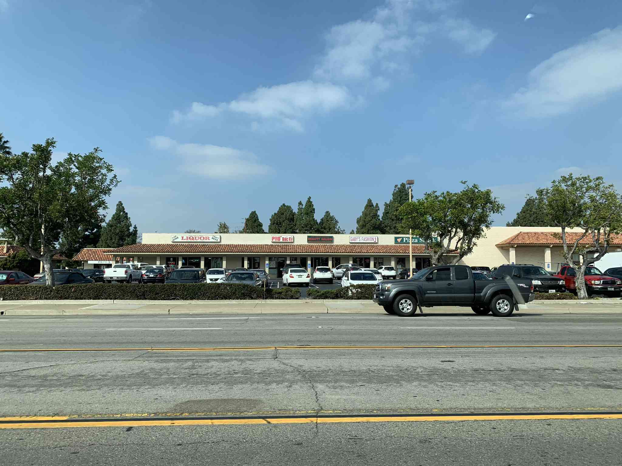
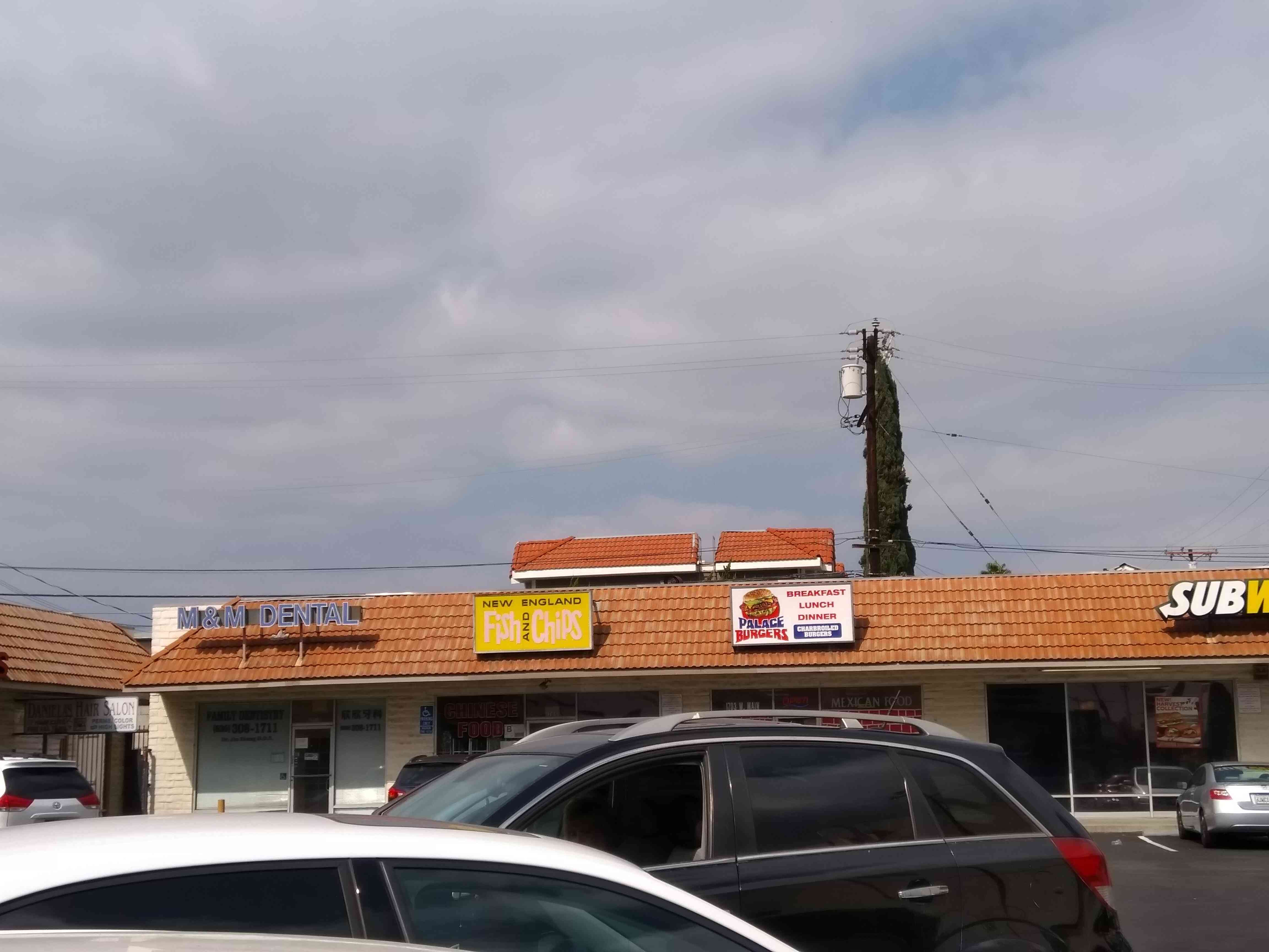
Informal surveying is generally when I have not prepared for surveying. I used to keep a pad and pen in my car for these few-minute surveying opportunities, but I can never consistently remember to bring the paper back into my car after inputting data, so informal surveying is a good time to leverage a cell phone. If I have a few minutes to burn, I’ll try to find a nearby strip mall or shopping center and take photos of the stores and signs at a few angles. Essentially, I want to build a photographic representation of the small store area so I can go home, look at the photos compared to satellite imagery, and input the data. This could also work if you are stuck at a stop light and are a passenger in a car, where you can take photos of stores or strip malls near the intersection to add later. Here are a few examples:
Street-level photos
Street-level photos are an advanced feature of some of the big mapping companies, and it is a feature that requires a lot of investment to drive cars with cameras down every street. Obviously this cannot be matched by a single mapper, but the idea of projects such as OpenStreetCam and Mapillary is to crowdsource this imagery in an attempt to compete with the big mapping companies feature. One component of the mapping street-level photo projects is that, while the imagery may not cover every square mile of road, the imagery that is there may be more up-to-date and possibly even cover the change over time.
My contribution to these projects is a bit more sporadic because of the time and fuel investments. Originally, I used the Mapillary app on my HTC One M9 and took absolutely beautiful photos of drives:
I then bought a few burner phones to capture side angle photos, which were not the best but not too bad either:
Somewhere along the way, the app became unstable on my phone and then my phone later gave up after five years, so I had to move on. A Black Friday deal led to a fairly priced GoPro Hero 5. While I had previous GoPro versions, they did not have a GPS, and I gave up very swiftly on trying to match photos to a GPS track taken by my phone (I still have four long drives in Texas sitting on my hard drive awaiting this work). The Hero 5’s GPS, though, makes it an all-in-one solution to this problem. I take the time lapse and upload the photos because they are already tagged with GPS. I like to make sure the tracks have only useful photos and that minor issues like GPS heading are fixed, so I have a somewhat lengthy process I follow to split the photos up into sequences, remove bad photos, correct any GPS errors, and then contribute the photos to both OpenStreetCam and Mapillary. This came in handy in time for house hunting in LA and the drive from Wisconsin to California. Here are a few shots:
Armchair mapping
As I mentioned in surveying, many companies have donated satellite imagery that can be used in OpenStreetMap. In addition, other projects like OpenStreetCam and Field Papers (where people can upload surveying data) provide data for use in OSM. “Armchair” mapping is the process of editing OpenStreetMap using only that imagery–and perhaps some older personal knowledge. The idea here is a few-fold: that some features like buildings and roads are not in the database and can be traced from imagery, that some features like stop lights or trees or POIs are not in the database but can be easily identified from imagery, and that some features like route relations or previously imported data are in the database but could use some cleanup (either by improving accuracy or just cleaning them up). This is one of the OSM activities you can work on in your free time when you are homebound or just can’t be bothered to go out. I contribute fairly extensively in this manner.
Note I also included old personal knowledge in this category. There is information that we gather in our day-to-day lives that may seem insignificant but is still missing in the database. This would fall along the lines of unintentional surveying, where you have the experience of a place by visiting or using it as opposed to collecting that memory for the purpose of mapping. Oftentimes this is older knowledge from another place you used to live, a place you visited a while ago, or just generally somewhere you are familiar with that you later revisit in your mind to help in mapping.
Map data input process
Whether armchair or surveyed mapping, I tend to use the Java OSM Editor, or JOSM, for inputting data into OpenStreetMap. It is a desktop application, meaning you have to install it on your computer. There is a somewhat steep curve in learning how to use JOSM, but once learned it is a very powerful tool. I have JOSM both on my desktop at home as well as my laptop that I use when traveling. There are even addons to load OpenStreetCam and Mapillary imagery in the editor. For very small fixes or additions on the road, I occasionally use the iD Editor. iD is designed to be beginner-friendly and it runs in your browser, so no installation is required.
Software contributions
All of OpenStreetMap runs on software, and open source software at that. If tracing satellite imagery or surveying data does not pique your interest, then developing software in the OpenStreetMap ecosystem may be something that interests you. One project I help with is the Tasking Manager sponsored by Humanitarian OpenStreetMap Team, where I am the lead volunteer developer. The TM is a tool that facilitates mapping projects by splitting up an area into a grid to ensure people do not create data conflicts by editing the same thing at the same time and tracking completion progress. You can check out a live version at tasks.hotosm.org.
During my tenure with the Data Working Group, I worked on a tool for tracking and notifying on edits by specific users or to specific objects called the Hall Monitor. This is a needed functionality, particularly for editors who are creating conflicts or issues. I had initially planned to include a module that was responsible for finding “suspicious edits” (people importing when they shouldn’t, people adding copyrighted data, people vandalizing, and so on), but other tools like OSMCha and Pascal Neis’ suspicious changesets have come up in the mean time. Outside of all of this, companies who use OpenStreetMap data have decided to hire staff to manually review edits too.
OSM Foundation Working Groups
The OSM Foundation is the non-profit group supporting OSM. Along those lines, the OSM Foundation has a variety of working groups staffed by volunteers that provide assistance to the project. Groups like the Operations Working Group keep the computer systems running and the Licensing Working Group handles licensing issues that may arise. I spent four years on the Data Working Group, who are tasked with handling user conflicts, investigating data where provenance is unknown, and guiding data policy.
One of the more contentious tasks of the DWG is working on country disputes. There are a large number of international disputes regarding land sovereignty and ownership. For a project that tries to represent the real world in the digital world, these conflicts come into play as well. Many of these conflicts are not widely known outside of the affected region, so the DWG has a monumental task in dealing with the conflicts. There is some guidance on disputed boundaries to generally follow the on-the-ground principle.
Closing
Hopefully this has provided you with a better understanding of how I personally contribute to OpenStreetMap. There are lots of other areas here not covered, like governance and outreach (I have given talks on OSM in the past), that others contribute with. In any case, OpenStreetMap survives and relies on dedicated volunteers doing things they like (and sometimes things they don’t) to keep this going. If you are interested in the project, find something you enjoy doing and try to apply it to the ecosystem!